

Montana Highway 86 (Bridger Canyon Road)
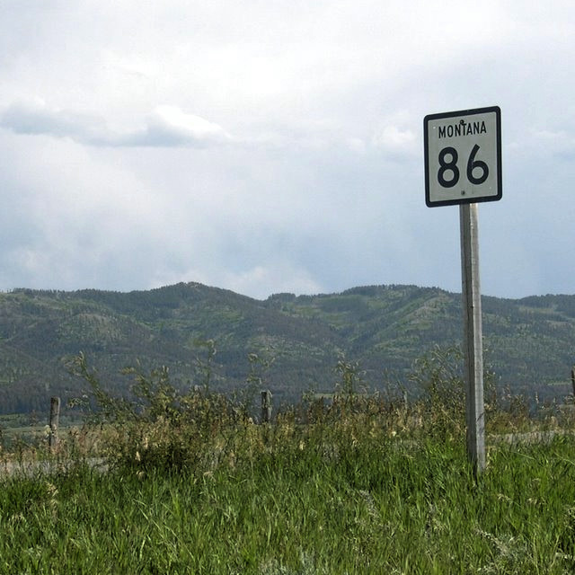 Montana Highway 86, also called Bridger Canyon Road, is a route running in a northerly direction from the city of Bozeman to an intersection with U.S. Route 89 just North of the town of Wilsall. This scenic drive covers a distance of approximately 38 miles (61 km) through Bridger Canyon, which has been protected from over development since 1971.
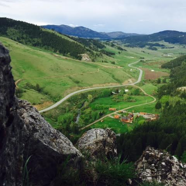
The route follows the Bridger Mountain Range to the west, and the Bangtail Mountains to the east, both of which are part of the Gallatin National Forest. The road provides access to the Bridger Bowl ski resort, Bohart Ranch Cross Country Ski Center, and has numerous options for Forest Service access.
Montana Highway 86, also called Bridger Canyon Road, is a route running in a northerly direction from the city of Bozeman to an intersection with U.S. Route 89 just North of the town of Wilsall. This scenic drive covers a distance of approximately 38 miles (61 km) through Bridger Canyon, which has been protected from over development since 1971.
The route follows the Bridger Mountain Range to the west, and the Bangtail Mountains to the east, both of which are part of the Gallatin National Forest. The road provides access to the Bridger Bowl ski resort, Bohart Ranch Cross Country Ski Center, and has numerous options for Forest Service access.
 There are several Bridger Canyon Campgrounds located along the drive where the route passes through the National Forest. These campgrounds tend to fill up quickly during the summer, especially on weekends.
The road begins at the Northern end of Rouse Ave as it turns to the east and leaves the city. It passes beneath the “College M” on the left, a 250-by-100-foot (76 m × 30 m) limestone majuscule M built into the side of “Old Baldy” within sight of Bozeman and Montana State University. There is a parking lot there for the “M” trail head, a popular hiking route.
There are several Bridger Canyon Campgrounds located along the drive where the route passes through the National Forest. These campgrounds tend to fill up quickly during the summer, especially on weekends.
The road begins at the Northern end of Rouse Ave as it turns to the east and leaves the city. It passes beneath the “College M” on the left, a 250-by-100-foot (76 m × 30 m) limestone majuscule M built into the side of “Old Baldy” within sight of Bozeman and Montana State University. There is a parking lot there for the “M” trail head, a popular hiking route.
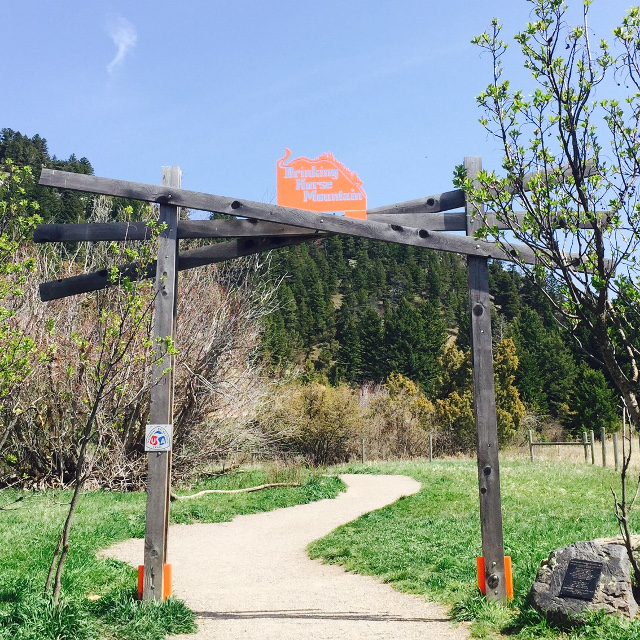 To the right is the parking lot and trail head for 2.1 mile “Drinking Horse” trail, and the Bozeman Fish Technology Center. The Bozeman Fish Technology Center (BFTC) is one of six Fish Technology Centers within the U.S. Fish and Wildlife Service’s Fisheries and Habitat Conservation Program.
The road winds past what was once a prominent rock spire known as Maiden Rock.
To the right is the parking lot and trail head for 2.1 mile “Drinking Horse” trail, and the Bozeman Fish Technology Center. The Bozeman Fish Technology Center (BFTC) is one of six Fish Technology Centers within the U.S. Fish and Wildlife Service’s Fisheries and Habitat Conservation Program.
The road winds past what was once a prominent rock spire known as Maiden Rock.
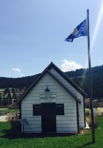 Near the 7 mile marker at the intersection of Highway 86(Bridger Canyon Road) and Kelly Canyon Road is the Bridger Canyon Schoolhouse, which is a one-room schoolhouse built in 1897, and preserved by Bridger Canyon residents as a community center.
Between the 9 and 10 mile marker is the intersection of Highway 86(Bridger Canyon Road) and Jackson Creek Road. Jackson Creek Road joins back up with Interstate 90 at Exit 319 on the Bozeman Pass.
At about the 15 mile marker, the road reaches Bridger Bowl Ski Area. During winter, Bridger Bowl is the place to come for superb skiing, as the ski area receives nearly 400 inches of now a year and has some of the best extreme skiing in the United States.
After Bridger Bowl the route passes Bohart Ranch and Crosscut Ranch, well known for Cross Country skiing, and for Nordic ski races and Biathlon competitions.
The road continues to gain elevation past Ross Peak Ranch and enters the National Forest. Once the road enters the National Forest, the views are a bit more limited due to the thick forest, but there are still beautiful views of the Bridger Mountains.
Near the 18 mile marker is the Bracket Creek intersection, which roughly marks the halfway point of the route.. Brackett Creek Road connects with Clyde Park and Montana Highway 89 15.3 miles to the east.
Near the North end of Highway 86, the road takes a 90 degree turn to the right and you will begin to see the Crazy Mountain range in the distance looking East.
The road flattens out, continues on toward the intersection with Highway 89, just north of the town of Wilsall.
Near the 7 mile marker at the intersection of Highway 86(Bridger Canyon Road) and Kelly Canyon Road is the Bridger Canyon Schoolhouse, which is a one-room schoolhouse built in 1897, and preserved by Bridger Canyon residents as a community center.
Between the 9 and 10 mile marker is the intersection of Highway 86(Bridger Canyon Road) and Jackson Creek Road. Jackson Creek Road joins back up with Interstate 90 at Exit 319 on the Bozeman Pass.
At about the 15 mile marker, the road reaches Bridger Bowl Ski Area. During winter, Bridger Bowl is the place to come for superb skiing, as the ski area receives nearly 400 inches of now a year and has some of the best extreme skiing in the United States.
After Bridger Bowl the route passes Bohart Ranch and Crosscut Ranch, well known for Cross Country skiing, and for Nordic ski races and Biathlon competitions.
The road continues to gain elevation past Ross Peak Ranch and enters the National Forest. Once the road enters the National Forest, the views are a bit more limited due to the thick forest, but there are still beautiful views of the Bridger Mountains.
Near the 18 mile marker is the Bracket Creek intersection, which roughly marks the halfway point of the route.. Brackett Creek Road connects with Clyde Park and Montana Highway 89 15.3 miles to the east.
Near the North end of Highway 86, the road takes a 90 degree turn to the right and you will begin to see the Crazy Mountain range in the distance looking East.
The road flattens out, continues on toward the intersection with Highway 89, just north of the town of Wilsall.
Category : Bridger Canyon Information