


Bridger Mountain Range
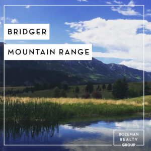 The Bridger Range lies to the west of Bridger Canyon and is part of the Gallatin National Forest. The Bridger Mountain Range hosts Bozeman’s hometown ski hill (Bridger Bowl) and a varied collection of nearby trails that are great for an afternoon hike. Elk, deer and mountain goat can often be seen on the western side of the ridge where open meadows provide good foraging and the forested hillsides good cover. Bridger Canyon is famous for the yearly raptor migration. Each autumn, usually in the first two weeks of October, you can view these magnificent birds of prey on their migration south. Over 200 Golden Eagles may be observed in a single day!
The Bridger Range was named after Jim Bridger who pioneered a trail through the mountains in Southern Wyoming into the Bighorn Basin in the year 1864.
Bridger Mountain Range Campgrounds
The Bridger Range has two primary campground areas on National Forest Service land. Fairy Lake campground and Battle Ridge campground.
Bridger Mountain Range Peaks
The tallest peak in the range is Sacagawea Peak (9665 ft/2,946 m) followed by Hardscrabble Peak (9575 ft/2918 m), Saddle Peak (9162 ft/2793 m), Ross Peak (9004 ft/2744 m), Mount Baldy (8914 ft/2717 m), and Bridger Peak (8635 ft/2632 m).
Sacagawea Peak
Sacagawea Peak (9665 ft/2,945 m) is the highest point in the Bridger Range. It’s prominence is 1203 m (3946 ft) above Bozeman Pass. This ranks Sacagawea Peak at 19th in Montana for prominence. The Fairy Lake trailhead is the most popular access point for climbing this peak. Fairy Lake offers camping (w/outhouse) and very good fishing, located less that 1/4 mile away on a well maintained trail. The road to Fairy Lake campground from Montana Hwy 86 is often closed until at least the 1st of July.
Hardscrabble Peak
“Hardscrabble Peak (9575 ft/2918 m) is a beautiful alternative to the very popular Sacajawea Peak as it is accessible from the same trailhead at Fairy Lake. Between Hardscrabble Peak and Sacajawea there are two unnamed peaks also providing beautiful views. From the top of any of these peaks a plethora of mountain range are visible including The Crazy Mountains, Gallatin and Madison Ranges, the Beartooths, and the Tobacco Root Mountains. This peak is an easy day hike and can be accessed at any time of the year.
Saddle Peak
Saddle Peak (9160 ft/2792 m) is located to the north of Baldy Mountain. It is one of the more prominent bumps on the long sharp ridge of the Bridger Range. Impressive views from the summit include the Gallatin Range, Madison Range, the Crazy Mountains, the Absaroka Range and the Tobacco Root Range. Much of southwest Montana is visible from this highpoint. This peak has several routes to choose from in order to summit.
Ross Peak
Ross peak (9003 ft/2744 m) is the fourth highest peak in the Bridger Range. It is located next to the unique Ross Pass which gives the craggy peak a bit of prominence when viewed from the East and West. Of the ten peaks in the Bridger Range, Ross Peak is located fifth from the South. One will find Ross Peak’s summit on the Saddle Peak USGS 7.5 minute quadrangle map. Both class two, class three and technical summits are possible on Ross Peak. Winter ski descents are common in the Banana Couloir as well.
Bridger Mountain Range Lakes
The best known lake in the Bridger Mountain Range is Fairy Lake. Fairy Lake is a gorgeous glacial green lake in a forested bowl at the base of Sacagawea Peak. The trail loops around the perimeter of the lake for an easy 1.2 miles. This is a great place to have a picnic, fish, and swim. The trail is primarily used for hiking and is accessible from May until October. The lake is a short distance from the Fairy Lake Campground.
Frazier Lake is smaller, and located approximately 1 mile further to the north at 8,100 feet elevation. The ridgeline above Frazier Lake is a knife’s edge, plummeting more than 1,000 vertical feet to the talus slopes below. The most popular route to Frazier Lake is Shafthouse Trail #540, which begins at Fairy Lake Road, about a mile short of the Fairy Lake campground. There isn’t an established parking area at the trailhead, but the trail sign is visible enough. The trail proceeds steadily uphill through meadows with great views and abundant wildflowers. Frazier Lake can also be accessed by a trail off Frazier Creek, which is accessed off of USFS Road 75 located on the north side of Fairly Lake road, about 4 miles from Highway 86. Road 75 is gated after about a quarter mile and is now closed to motor vehicle traffic. There is parking for a couple of vehicles by the gate and it is a 4 mile hike or bike ride north to Frazier Creek.
Category : Bridger Canyon Information